By continuing to browse this site you permit us and our partners to place identification cookies on your browser and agree to our use of cookies. Review our Cookies Policy for details.
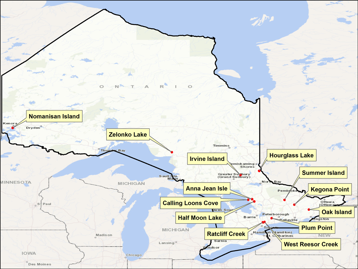
The Ontario Geographic Names Board has received nine name proposals and wants to hear from residents who know any local name(s) for the features highlighted on the map.
Based on your feedback, the Board may make a recommendation to the Ministry of Northern Development, Mines, Natural Resources and Forestry to officially adopt the proposed name. Official names appear on government maps and publications.
If you are familiar with these features and would like to comment, please complete a short survey by November 30, 2022.
Anna Jean Isle: Located about five kilometres northeast of Parry Sound, on the east end of Mill Lake, at the outlet of Haines Creek, in the municipality of McDougall, in the District of Parry Sound.
Calling Loons Cove: Located in Georgian Bay adjacent to the north shore of Rose Island, south of Killbear Provincial Park, in the Township of Carling, in the District of Parry Sound.
Half Moon Lake: Proposed name change for Little Portage Lake in the Township of Seguin, in the District of Parry Sound.
Hourglass Lake: Located between Temagami and the Ontario/Québec border, about one kilometre south of Fourbass Lake and north of the Matabitchuan River, Township of South Lorrain, District of Timiskaming.
Irvine Island: The largest and most north-westerly island in Little Otter Lake in Wanapitei Provincial Park, in the City of Greater Sudbury.
Kegona Point: Located south of Whale Point Island and north of Bald Island, on the east shore of Weslemkoon Lake, in the Township of Ashby, County of Lennox and Addington.
Nomanisan Island: Located just south of Anchor Island and east of Houghs Island in Lake of the Woods. About 10 kilometres south of Kenora, in the District of Kenora.
Oak Island: Located on the north end of Bobs Lake, on the very western edge of the Township of Tay Valley, in the County of Lanark.
Plum Point: Located on the north shore of the east end of Lake Scugog, in the City of Kawartha Lakes.
Ratcliff Creek: A creek flowing south into Little Rouge Creek in the town of Whitchurch-Stouffville.
Summer Island: The only island on Lake St. Peter north of Maynooth, in McClure township, County of Hastings.
West Reesor Creek: A creek draining south into Reesor Creek on the northeast side of Stouffville, in the Town of Whitchurch-Stouffville, and the Township of Uxbridge.
Zelonko Lake : Hugging the east side of Ontario Highway 17, approximately 29 kilometres north of Wawa along Highway 17 and south of Obatanga Provincial Park.
About geographic names
Geographic names help us describe our surroundings and identify historic, cultural and natural features on the landscape.
reviews applications for new names for unincorporated places (e.g., villages, hamlets) and geographic features (e.g., lakes, rivers, hills, valleys)
submits recommended geographic feature names to the Minister of Northern Development, Mines, Natural Resources and Forestry for approval in accordance with the Ontario Geographic Names Board Act
When recommending names, the Board:
follows the principles and procedures it has put in place
confirms that names are used and supported by the community
A spatial database of official geographic feature and unincorporated place names (in English, French and First Nation languages) is maintained by the Ministry of Northern Development, Mines, Natural Resources and Forestry.
requests that do not comply with the principles will not be considered
the Board primarily considers the local usage of a name
commemorative names are reserved for those who made an outstanding contribution to a local area, Ontario or Canada
land ownership on its own does not warrant changing a well-established name
the Board does not support commemorative names for living persons
the Board does not endorse naming contests or competitions and will not accept the results of these activities
Step 2: Send an email to [email protected] to request a submission form.
Don’t forget to attach relevant documentation that will support your name request. Your submission will be reviewed by the Board for potential approval. This process can take up to 12 months.
For more information
The Ontario Geographic Names Board Mapping and Information Resources Branch Ministry of Northern Development, Mines, Natural Resources and Forestry 2nd Floor North 300 Water Street Peterborough ON K9J 8M5